Winter 2021-22 Forecast 2 years ago
October 28, 2021
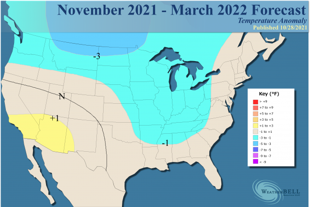
- We have made the forecast a bit colder than the first two issuances.
- The expected fast start to winter from the Plains eastward will happen as outlined.
- There is strong analog support from models through mid-winter.
- Overall the coldest weather should be centered on the northern Plains and Canadian Prairies with intrusions farther to the south and east.
The snowfall map remains the same:
.png)
Winter pattern Hypothesis (updated)
The established major warmth over central North America to start October has been undercut as we thought as the jet in the Pacific is slamming into the Northwest. Then, it will send energy into the southern Plains. We did not see a named tropical storm but what slammed New England is an example of what that warm water can do. Since the northwestern Atlantic is so warm, it is more than happy to contribute to the ridging. So this will continue to work its way to the northeast, and once over northeastern Canada and Greenland, the trough can run rampant underneath. Then whether cold air can be delivered over the U.S. becomes a matter or source-regions of the air masses. The threat of early severe cold relative to averages remains and we are pointing at the Thanksgiving to New Years' period as the coldest of what is now a more obvious forecasted colder turn starting.
However, as this process continues, the combination of the MJO likely advancing and feedback that occurs in the subtropics as the jet strengthens over the southeastern U.S. will start forcing the Southeast ridge to appear. Then it will become a fight between that and the cold air that can drain into the U.S. and push.
The new analog pattern is from the team. It has many of the long terms ones we have had, but others have been added as members of the team contribute extra flavoring to the brew. It is a winter where short-term weather forecasts may be ultra-important. Unless you get a total breakdown as we saw in the 1989 and 1950 cold starts, there will be enough activity to warrant plenty of concern. Even as 2018 fell apart, December of that year and 2017-18 found the MJO stuck in Phase 7 in February before the wild March comeback. God help us all if we ever run a winter coast to coast (November-March). The last one really was 2013-2014 and before that 1995-96 as they were more common before the Atlantic warmed. Though there have been no hurricane hits in October, this Nor'easter certainly means something and there could still be a development in November. That being said, the ACE index for October globally is near the 2008 analog season and that year saw almost no action in October. In any case, the modeling is trending colder and headed toward our idea.
The Verdict
The turn to a colder pattern has begun, and assuming this works out to the degree our forecast has it will add another year to the analog package of a high amplitude MJO in the spring, the cold May, the high impact hurricane season, and then a cold start to the winter. However, keep in mind that the signal diverges after that.
There is enough variance and timing of the swing, so prepare for bursts of higher than normal wintery weather, followed by a backing off. The wintery period will outduel the milder periods for the end result being a bit snowier than normal (population-weighted) with near-normal temperatures overall.
The antics of the MJO will be huge. Models unfortunately are horrible at forecasting it, but I hope you have noticed that since the spring of 2020 we have had skill in hitting what it's up to. The MJO has also been a big help in 1-2 month forecasting for everything from summer cooldowns to hotter periods and hurricanes.
In the end, we have tweaked the temperature forecast some to home in on the final forecast idea.